Call or Text
Book Online — fastest wayGuided ToursContact
Rentals & services
Off-road riding areas
- Sand Hollow
- Arizona Strip
- Babylon Arch Trail
- Black Rock Canyon
- Bryce Canyon
- Coral Pink
- Diamond Valley
- Elephant Arch
- Flintstone House
- Fort Pearce & Dinosaur Tracks
- Goldstrike Trail
- Gooseberry Mesa
- Grand Canyon
- Green Valley Trail
- Hell Hole Pass
- Honeymoon Pack
- Horsefly Cliff
- Little Black Mountain
- Little Sahara
- Milt’s Mile ATV Trail
- Moe's Valley
- Mojave Desert
- Nasty Half Trail
- Pine Mountain
- Sand Mountain
- Smithsonian Butte
- Smubrfette's Trail
- Sun River Bonnie
- Sunshine Trail
- The Maze Trail
- Toquerville Falls
- Utah Redwood Tree
- Warner Valley
- Wayne’s World
- West Rim Trail
- Yant Flat & Candy Cliffs
- Zion National Park
Lakes & reservoirs
- Antelope Point
- Bear Lake
- Bullfrog Marina
- Deer Creek
- East Canyon
- Echo State Park
- Flaming Gorge
- Gunlock Reservoir
- Halls Crossing
- Hyrum Reservoir
- Joes Valley
- Jordanelle
- Lake Powell
- Navajo Lake
- Pineview Reservoir
- Quail Creek
- Red Fleet
- Rockport State Park
- Salt Lake
- Sand Hollow Resort
- Scofield Reservoir
- Starvation Lake
- Steinaker Lake
- Strawberry Lake
- Utah Lake
- Wahweap Marina
- Willard Bay
- Yuba Lake
Areas we serve
- American Fork
- Bountiful
- Brigham City
- Cedar City
- Clearfield
- Clinton
- Cottonwood Heights
- Draper
- Eagle Mountain
- Farmington
- Herriman
- Highland
- Holladay
- Hurricane
- Kaysville
- Kearns
- Layton
- Lehi
- Logan, Utah
- Magna
- Midvale
- Millcreek
- Murray
- Ogden
- Orem, Utah
- Payson
- Pleasant Grove
- Provo, Utah
- Riverton
- Roy, Utah
- Salt Lake
- Sandy, Utah
- Saratoga Springs
- South Jordan
- Spanish Fork
- Springville
- St George
- Syracuse
- Taylorsville
- Tooele
- Utah County
- Washington
- West Jordan
- West Valley
Open 7am–10pm, every day · 866-494-7760

St. George Off-Road Map with Live GPS
Every riding area we serve around St. George, Hurricane and Sand Hollow on one map, with a live blue dot that shows where you are. Save it before you leave town and it keeps working with no cell signal.
Ride Finder
Pick what matters and the map lights up the rides that fit.
Who’s riding?
What do you want to see?
How long?
St. George area riding map
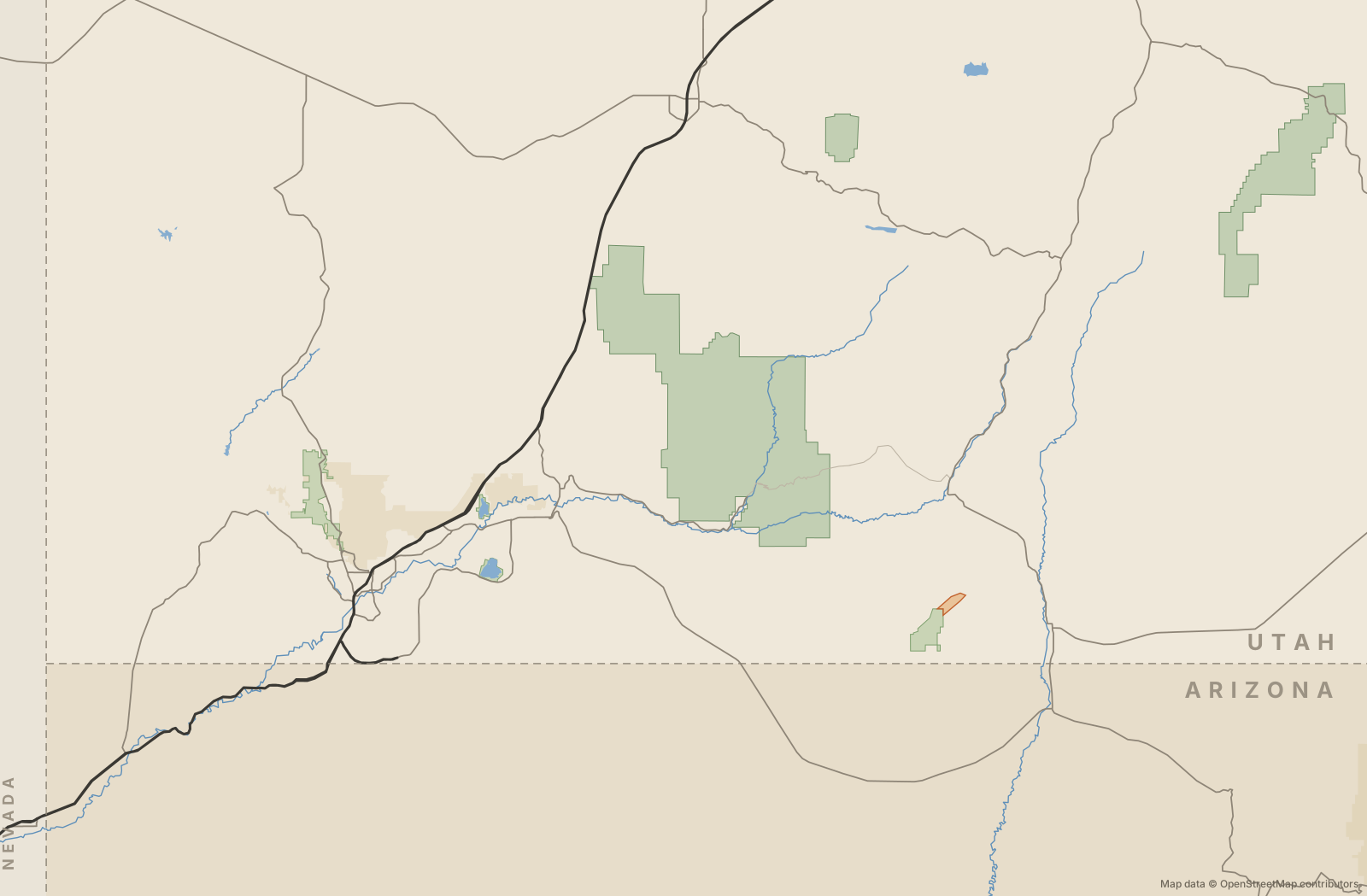 St. GeorgeHurricaneWashingtonSanta ClaraIvinsLa VerkinSpringdaleKanabCedar CityMesquiteHildaleLeedsVeyoEnterpriseFredonia1Sand Hollow2Sand Mountain3Warner Valley4Fort Pearce & Dinosaur Tracks5Sunshine Trail6Honeymoon Trail7Arizona Strip8Little Black Mountain9Elephant Arch10Green Valley & Bloomington Bluff11Sun River Bonnie12Moe's Valley13Black Rock Canyon14Hell Hole Pass & TV Towers15Joshua Tree Backway16Goldstrike & Lone Pine Arch17Diamond Valley18Pine Mountain19Yant Flat & Candy Cliffs20Babylon Arch21Toquerville Falls22Utah Redwood Tree ride23Smithsonian Butte24Gooseberry Mesa & Hurricane Cliffs25Rides near Zion26Virgin River Gorge27Coral Pink Sand Dunes
Tap a numbered pin for the riding guide. Sand Hollow’s named trails are on the detail map below.
Sand Hollow trail detail
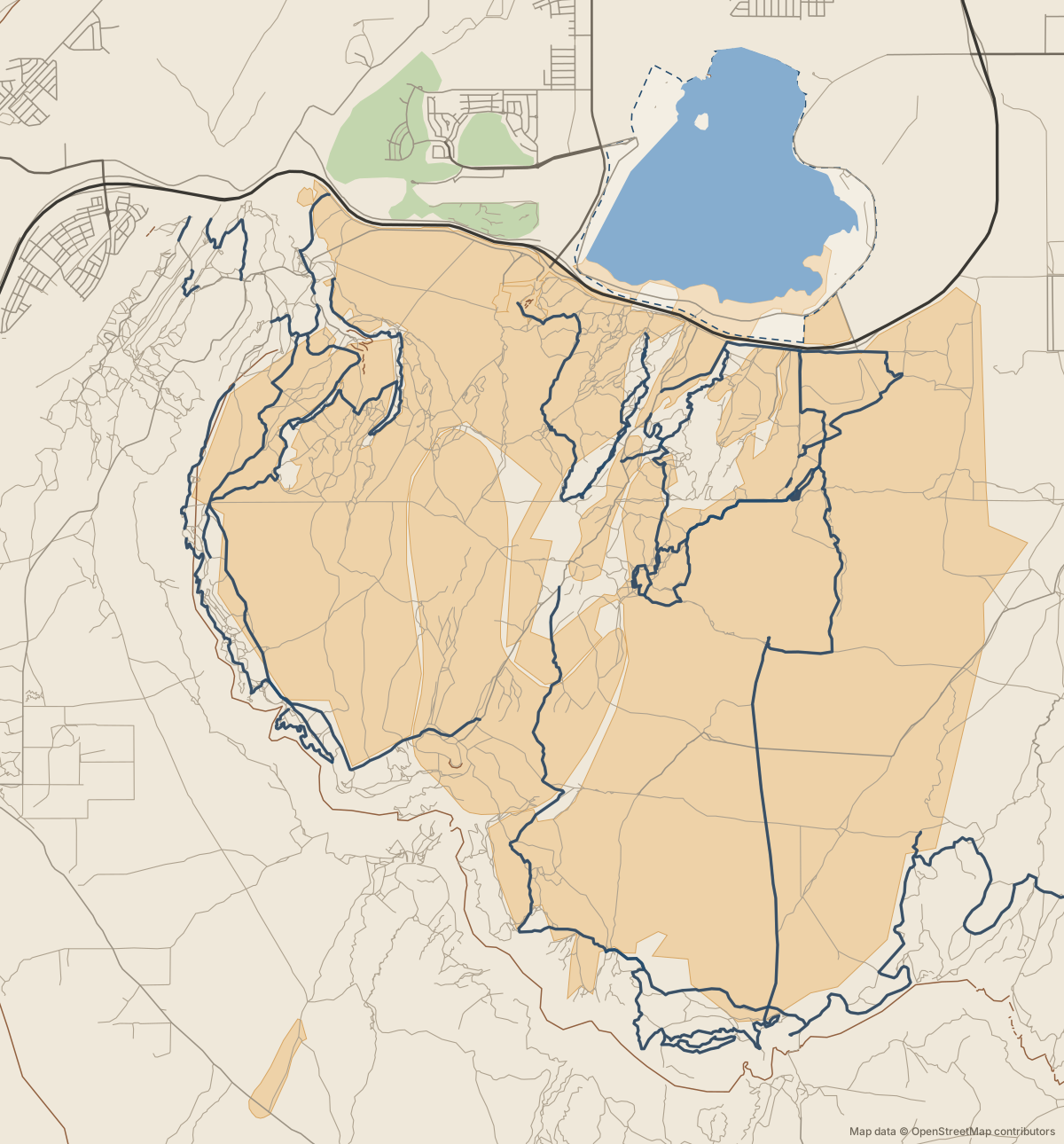
Blue lines are Sand Hollow’s named trails; orange lines are other mapped tracks. Sand dunes are shaded tan.
Every riding area on the map
- Sand HollowAll levels · Half or full dayabout 7 mi from Hurricane
- Sand MountainModerate · Half dayabout 7 mi from Hurricane
- West Rim TrailModerate · 2–4 hoursabout 10 mi from Hurricane
- Wayne's WorldEasy to moderate · 1–2 hoursabout 7 mi from Hurricane
- Milt's MileModerate to technical · 1–2 hoursabout 8 mi from Hurricane
- The MazeTechnical · 2–3 hoursabout 11 mi from Hurricane
- Nasty HalfTechnical · 1 hourabout 8 mi from Hurricane
- Smurfette'sModerate · 1 hourabout 9 mi from Hurricane
- Flintstone HouseEasy to moderate · 2–3 hoursabout 9 mi from Hurricane
- Warner ValleyEasy · Half dayabout 13 mi from Hurricane
- Fort Pearce & Dinosaur TracksEasy · Half dayabout 13 mi from Hurricane
- Sunshine TrailModerate · Full dayabout 14 mi from Hurricane
- Honeymoon TrailModerate · Half to full dayabout 13 mi from Hurricane
- Arizona StripModerate · Full dayabout 23 mi from Hurricane
- Little Black MountainEasy · 2–3 hoursabout 22 mi from Hurricane
- Elephant ArchModerate · Half dayabout 22 mi from Hurricane
- Green Valley & Bloomington BluffModerate · 2–3 hoursabout 19 mi from Hurricane
- Sun River BonnieModerate · 1–2 hoursabout 20 mi from Hurricane
- Moe's ValleyEasy · 1–2 hoursabout 20 mi from Hurricane
- Black Rock CanyonEasy to moderate · Full dayabout 16 mi from Hurricane
- Hell Hole Pass & TV TowersModerate · Half dayabout 23 mi from Hurricane
- Joshua Tree BackwayEasy · Half dayabout 30 mi from Hurricane
- Goldstrike & Lone Pine ArchModerate · Full dayabout 34 mi from Hurricane
- Diamond ValleyModerate · Half dayabout 19 mi from Hurricane
- Pine MountainModerate · Full dayabout 19 mi from Hurricane
- Yant Flat & Candy CliffsModerate · Half dayabout 12 mi from Hurricane
- Babylon ArchEasy to moderate · 1–2 hoursabout 4 mi from Hurricane
- Toquerville FallsModerate · Half dayabout 9 mi from Hurricane
- Utah Redwood Tree rideModerate · Half dayabout 11 mi from Hurricane
- Smithsonian ButteEasy to moderate · Half dayabout 13 mi from Hurricane
- Gooseberry Mesa & Hurricane CliffsModerate · Half dayabout 6 mi from Hurricane
- Rides near ZionEasy to moderate · Half dayabout 16 mi from Hurricane
- Virgin River GorgeTechnical · Half dayabout 35 mi from Hurricane
- Coral Pink Sand DunesAll levels · Full dayabout 32 mi from Hurricane
How to use the map on the trail
- Save it while you have signal. Tap Save for no signal at the top. The map, the Sand Hollow trail detail and Trail Help are stored on your phone.
- Turn on your blue dot. Tap Show me on the map. GPS works without cell service, so the dot keeps moving even where your phone shows no bars.
- Zoom in on the area you’re riding. Use the plus button, then scroll the map with your finger. Tap any pin for the full riding guide.
- Need us? Open Trail Help. It finds your coordinates and puts them in a text to us with one tap.
Plan your ride by the light
Southern Utah’s red rock is at its best in the last hour before sunset. The Golden Hour planner below shows tonight’s golden hour at Sand Hollow and the time to roll out so you’re on the dunes when it starts, along with the next five days of riding weather.
Next five days, with our quick read on each one. Loading the forecast… Forecast by Open-Meteo. Times are local to the riding area. 0 of 10 ready Your checks stay on this phone, so you can tick things off the night before.Riding weather at Sand Hollow
Golden HourRide Ready checklist
Map questions
Does the map work without cell service?
Yes, once you save it. Saving stores the map pages on your phone, and your phone’s GPS finds your position from satellites, not cell towers. Save it in town before you head out.
Is this the same as a trail map from the park?
It’s our planning and navigation map for the areas we ride, drawn from OpenStreetMap data. Distances on the list are straight-line miles, so the drive is usually a bit farther.
Can I get a guide instead?
Yes. Add a guide to any rental while you book online, for any length of ride, and we’ll take you to the best spots for your group.
Book online Booking online is the fastest way to book. Questions? Call or text 866-494-7760, open 7am–10pm every day.